Hello. I'm Natsumi Kadowaki from the Coding Factory.
It has been about a year since I moved to Honmachi, Shibuya Ward.
Honmachi, located close to Shinjuku Station, is a town that exudes a down-to-earth atmosphere and a sense of everyday life, despite having the skyscrapers of Shinjuku in the background.
If you live in Honmachi and love it, there are many places that will interest you.
A shrine suddenly appears in a residential area, a steep slope, a former river culvert...
And I couldn't help but want to know more about this town.
This time, I've researched some things I'm curious about regarding Honmachi and would like to share them with you!
Welcome to Honcho, Shibuya Ward!
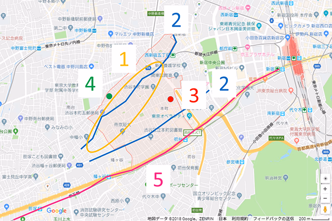 Figure 1: Map of the target area (present day) The area in the red frame in the center of the image is Honmachi. The numbers indicate locations 1 to 5 introduced in this article.
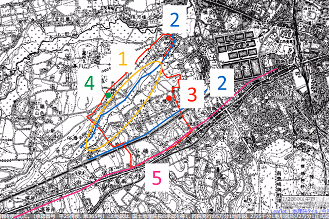
Figure 2: Map of the target area (around 1896-1909)
Same range as Figure 1.
The area surrounded by a red frame is "Honmachi" in Shibuya Ward.
To the north is Nishi-Shinjuku-go-chome Station on the Toei Oedo Line, and to the south is Hatsudai Station on the Keio Line.
The Fudo-dori shopping street runs east to west through the center of Honmachi.
Most of the town is residential, and Fudo-dori Shopping Street is a shopping area for the townspeople.
Figure 2 is a map from the Meiji period.
The area near Honmachi shopping street was a settlement, but much of the surrounding area appears to have been rice fields.
Nowadays, you can no longer see rice fields in Honmachi.
This time we will introduce locations 1 to 5 shown on the map above.
- Slope
- Two irrigation channels
- Shogonji Temple, which has existed since the Sengoku period
- Honmachi's guardian deity "Hikawa Shrine"
- Keio Line
So, let's get going!
1. Lots of hills
Honmachi has a lot of slopes.
As I pedal my bike, I find myself thinking, out of breath, "Why are there so many hills...?"
I wondered why, and when I looked at the topographical map, I realized it was because this area was a valley.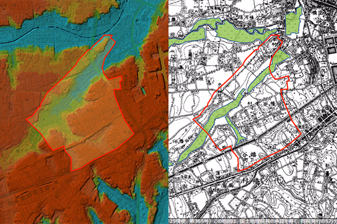
Figure 3 (left): A color-coded map of elevation from a modern topographical map (created from a Geospatial Information Authority of Japan map ).
Figure 4 (right): Topographical map from around 1896 to 1909. The green areas are rice fields. (Reprinted from Konjaku Map )
Looking at the elevation map on the left, you can see that there is a large valley in Honmachi.
This valley was once a river called " Izumigawa ".
However, the Izumi River cannot currently be seen in this town.
So why did it disappear? I'll explain that later.
Because water is easily available along rivers, rice paddies have been formed there since ancient times.
Looking at the map from the Meiji period shown on the right, we can see that the valley in the center was indeed used as a rice field.
Nowadays, there are no rice fields left and most of the land has been turned into residential areas.
2. Two irrigation canals that flowed through Honmachi (now extinct)
There used to be two irrigation canals in this area.
The first is the irrigation canal centered around the Izumi River, which is the blue line on the north side in Figure 2.
The second is the "Tamagawa Aqueduct New Waterway," which is the blue line on the south side in Figure 2.
Neither of these exist anymore.
First, let us introduce you to the irrigation canals centered around the Izumi River!
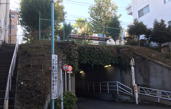
The Izumi River existed until the 1950s, but as urbanization progressed in the wake of the Tokyo Olympics, it was buried underground.
In addition to the Izumi River, there are several other rivers buried underground in Tokyo.
This is called an "underground drain."
The bridge is a remnant of the time when the river was above ground.
In Honmachi, there are many bridges without rivers, which is a strange sight.
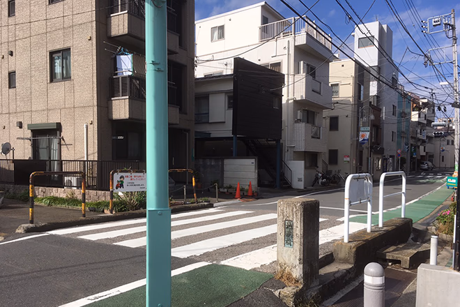
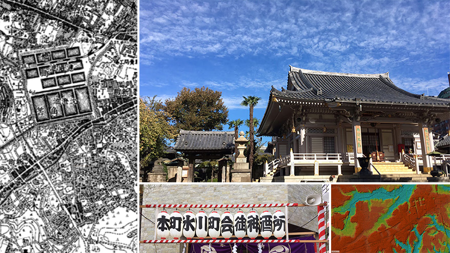
Jizo Bridge, an underground drainage system located in Honmachi 2-chome.
Another irrigation canal that was located in Honmachi was the Tamagawa Aqueduct New Canal (Tokyo City New Canal).
This is where the Tamagawa Aqueduct was located. It is now elevated.
The new Tamagawa Aqueduct was completed in 1898.
However, it suffered damage from several earthquakes, including the Great Kanto Earthquake (1923), and was closed in the early Showa period.
The location of the new Tamagawa Canal is now a major road, and an expressway also runs through it.
3. Shogonji Temple, the Fudo Myo-o in the Warring States Period
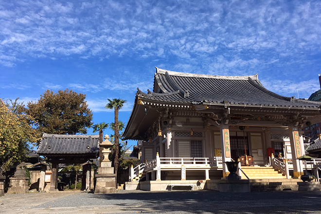
Shogonji Temple is located on a corner of Fudo Street.
When you enter Fudo-dori Shopping Street, after walking a short distance from the entrance, you will see the temple called "Shogonji Temple."
The oldest historical fact I have found about Honmachi is the description of Shogonji Temple.
"Shogonji Temple is a branch of the Otsukaku-ji Temple of the Shingon sect of Buddhism, also known as Komyo-san. Its founder is said to be Yuetsu. It was founded in the fourth year of the Eiroku era, and its grounds cover 10,000m2 of tax land, and includes the Fudo Hall."
Quoted from: Horikiri Morinosuke (ed.) (1978), Shibuya Library Local Materials: Hatagaya Local History, published by Shibuya Library, Shibuya Ward, Tokyo, p. 74.
I'm not sure...
Apparently, Shogonji Temple was founded in 1561.
At the entrance to Shogonji Temple, there is a monument engraved with a haiku poem by Matsuo Basho (1644-1694).
"Late evening, passing through Yotsuya, paper sandals"
It is clear that during the Edo period, there was a lot of traffic from the city center to this area.
Currently, the approach to Shogonji Temple is the Fudo-dori Shopping Street.
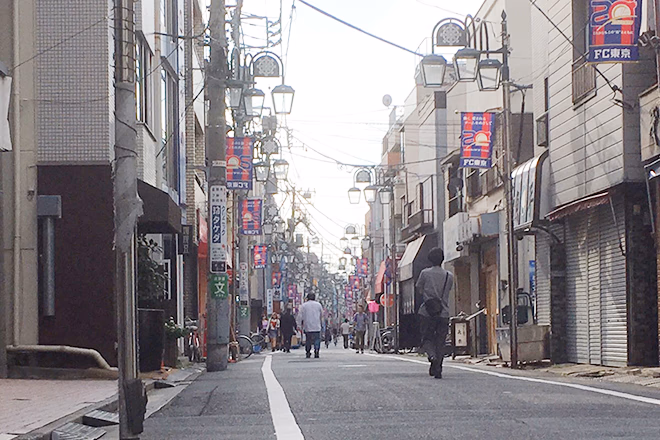
Honmachi Shopping Street. There are few chain stores, and many independent shops.
This historic shopping street still supports the lives of the townspeople!
4. Hatagaya Hikawa Shrine, the guardian deity of Honmachi
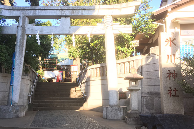
A view of Hatagaya Hikawa Shrine.
Hatagaya Hikawa Shrine is the guardian deity of this town.
Hatagaya Hikawa Shrine enshrines Susanoo-no-Mikoto, the god of agriculture, plague and the underworld, and Kushinada-hime, the river god.
As mentioned above, during the Meiji period, the area around Hikawa Shrine was rice fields.
There must have been an important connection between this town's agriculture and Hatagaya Hikawa Shrine.
In addition, in the fall, a two-day annual festival is held.
From early in the morning, people of the town carry the mikoshi (portable shrine) and parade through the surrounding area, and the sounds of spirited voices and beating drums can be heard, creating a very impressive sight.
At night, food stalls line the streets of Hikawa Shrine, attracting large crowds of people of all ages and genders.
Hatagaya Hikawa Shrine is located 2.6 km from JR Shinjuku Station, and I was impressed by how local events are still being carried out in the heart of Tokyo.
5. When did the Keio Line start operating?
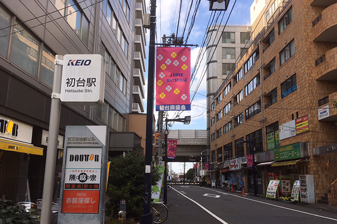
The Keio Line's "Hatsudai" station. In the background is the Koshu Kaido, which is a dual-use highway made up of a national highway and the Shuto Expressway.
The Keio Line railway line between Shinjuku and Sasazuka, south of Honmachi, opened on April 15, 1913.
I was surprised that it was older than I had imagined!
I wasn't able to check the tracks that were in place at the time, but currently Keio Line trains run underground under Koshu Kaido.
At the time, the vehicles had a capacity of about 30 people and traveled at about 13 km/h.
When the line opened in 1913, the annual number of passengers was 174,620, but by 1919 it had risen to 618,691.
The population is growing, trains are becoming more common, and the city center is thriving...
It can be imagined that this was a time when the area became more and more lively.
A touch of patriotism
One day, I was talking to a customer at a bar in Honmachi.
The person who was born and raised in Honmachi,
"Because Hatsudai Station (on the Keio Line) is nearby, some people call this area 'Hatsudai.'
But this isn't Hatsudai, it's Honmachi!"
Other customers and store staff agreed with what the customer had to say and joined in, and began talking about the differences with Hatsudai.
Hatsudai is a newly built town, while Honmachi is an old town.
I'm always happy when I come across this kind of patriotism in my new place or when I travel.
This is because it is not just a space that exists, but a place that someone cares about.
Those are the kind of places you'll want to visit again, even if you leave the town someday.
I was born and raised in Osaka, so it feels like a long journey to Tokyo.
Since I have the opportunity, I would like to get to know the many areas of Tokyo with affection.
You only live once, so make sure you enjoy the area where you live.
References:
Arita Hajime (1935) Shibuya Fudoki, published by Tokyo Asahi Press; Horikiri Morinosuke (ed.) (1978) Shibuya Library Local Materials: Hatagaya Local History, published by Shibuya Library, Shibuya Ward, Tokyo; Tani Kenji, Konjaku Map on the web, a website for viewing time-series topographical maps, Tani Kenji (Human Geography Laboratory), Faculty of Education, Saitama University < http://ktgis.net/kjmapw/ > Last accessed on 21 October 2018.
Honda Hajime, "From the waterless waterside... How to enjoy 'underground channels' Part 3: Tracing the mysterious Kanda River tributary from Nishi-Shinjuku." MIZBERING < https://mizbering.jp/archives/11943 > Last accessed on October 21, 2018.

モノサスアーカイブ